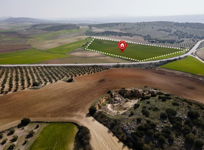
Can GIS Mapping Assist With Land Measurements?
In the previous blog, we have learnt how GIS Mapping companies in Chennai are helping businesses. Today, we are going to know about how GIS Mapping services can help your land measurements. Whether you're a land seller or buyer or want to build something where you need accurate measurements. Mapping services are crucial for land measurements and help you buy risk-free lands for your personal or commercial purposes. Let’s see how GIS Mapping services in Chennai can help you.
Accurate Land Measurement
GIS mapping uses satellite imagery, aerial photography, and survey data to accurately measure land parcels. By overlaying these data sources onto a digital map, GIS software can calculate precise measurements, including area, perimeter, and boundaries. This eliminates the need for manual measurements, reducing errors and providing reliable information for landowners and potential land buyers.
Parcel Identification
It assigns unique identifiers to each land parcel on a digital map. This enables efficient parcel identification and tracking helps to manage and sell properties. Real estate agents, developers, and government agencies can quickly locate specific parcels of land based on their unique identifiers, streamlining administrative processes.
Land Use Analysis
GIS mapping companies in Chennai provide detailed analysis of land use patterns. By overlaying different layers of data onto maps, such as zoning regulations, environmental factors, or demographic information, stakeholders can assess the suitability of land for specific purposes. This helps potential buyers evaluate the potential value and feasibility of a property based on its location and surrounding amenities.
Visual Representation
Mapping Services provides visual representations of land parcels that can enhance marketing efforts. Potential buyers can easily view the location and boundaries of a property on a map along with relevant information such as nearby amenities or transportation networks. This visual representation improves communication between sellers and buyers by providing a clear understanding of the property's characteristics.
Market Analysis
GIS mapping supports market analysis for real estate professionals. By integrating demographic data, market trends, and property values onto a map, analysts can identify emerging market trends and areas with high growth potential. This helps sellers determine competitive prices for their properties and target specific buyer segments more effectively.
Land Sales Planning
Mapping aids in planning land sales strategies. By analysing market demand, saturation levels, and competitor locations on a map, sellers can identify underserved areas or niche markets. This information helps in developing targeted marketing campaigns and optimising sales efforts.
Legal Documentation
GIS mapping provides a digital platform for storing and managing legal documentation related to land sales. Deeds, titles, easements, and other important documents can be linked to specific land parcels on a map, ensuring easy access and accuracy in legal proceedings.
Land Value Assessment
It also assists in evaluating land values by considering various factors such as proximity to amenities, transportation networks, and environmental attributes. This information helps sellers set realistic prices and negotiate effectively with potential buyers.


Comments
Post a Comment